The strike counter is reset at midnight each day
Not to be used for protection of life and property

Thunderstorm Color Strike rate/min Classification
Green 1-10 Weak Yellow 11-49 Moderate Red > 50 Strong or Severe
NWR Weather Static Lightning Image
Image updated every 5 minutes. Hit REFRESH for the latest image.
Note: The map
will display the best range for the current activity. From 25 - 1200 km.
The
strike counter is reset at midnight each day
Not to be used for protection of life
and property
Thunderstorm Color Strike rate/min Classification
Green
1-10 Weak
Yellow
11-49 Moderate
Red
> 50 Strong or Severe
|
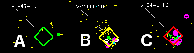
A Storm identification number V-4474. Dominating CG strike polarity is positive, last recorded strike rate per minute = 1, the strike rate per minute is not changing. The storm is categorized as Weak. |
B Storm identification number V-2441. Dominating CG strike polarity is negative, latest recorded strike rate per minute =10, the strike rate is increasing. It is categorized as Moderate. |
C |
-CG
-- Negative Cloud to Ground Strike
+CG -- Positive Cloud to
Ground Strike
-IC -- Negative Intracloud Strike
+IC -- Positive Intracloud Strike
The lightning detector is located in suburban Regina, Saskatchewan, Canada and provides particularly accurate for southern Saskatchewan, northeastern Montana and northwestern North Dakota but at night will detect strikes up to to 1200 km.
Unique
Visitors
Free Counters
Total Hits
Free Counters